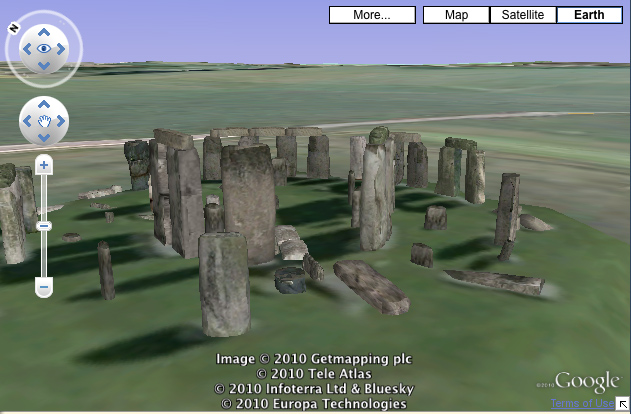
Google adds Earth's 3D images to its maps
Google Earth is now integrated into the mapping system.

Google Earth has now been added to the web giant's mapping system.
If viewing a site in Street View or via satellite imagery isn't enough, Google Earth will let users explore maps in 3D.
The integration puts Google Maps back alongside Bing's maps, as the Microsoft-run rival has offered its own 3D imagery of some sites for a while now.

Google has been working on bringing 3D Earth to its maps for years, first rolling out a system for developers in 2008.
Brian McClendon, vice president of engineering for Google Geo, said advances in web browser technology has allowed the 3D step forward. "As their capacity to handle richer applications has steadily grown, our ability to bring Google Earth online has grown along with it," he said in a blog post.
Aside from killing time getting lost in lovely scenery, what's the point of such 3D integration? "For instance, users can find a biking trail using the bike maps feature, then look at it in Earth view to see how hilly the route is," Google said in a statement.
"Or they can find a vacation spot by searching for the most attractive beaches in Earth view, then switch back to the Maps view to get a quick sense of what the nearest towns have to offer," it added.
Get the ITPro daily newsletter
Sign up today and you will receive a free copy of our Future Focus 2025 report - the leading guidance on AI, cybersecurity and other IT challenges as per 700+ senior executives
For more, check out the video from Google below:
Freelance journalist Nicole Kobie first started writing for ITPro in 2007, with bylines in New Scientist, Wired, PC Pro and many more.
Nicole the author of a book about the history of technology, The Long History of the Future.
-
 CISA issues warning in wake of Oracle cloud credentials leak
News The security agency has published guidance for enterprises at risk
By Ross Kelly
-
 Reports: White House mulling DeepSeek ban amid investigation
News Nvidia is caught up in US-China AI battle, but Huang still visits DeepSeek in Beijing
By Nicole Kobie